The storm, which has weakened into a tropical depression over central Laos on early August 26 morning, has caused significant disruption in urban centers, with continued warnings of landslides, flash floods, and further weather hazards in the hours ahead.
    |
 |
|
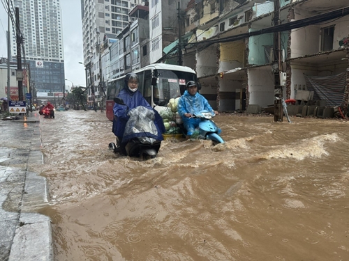
Flooding on Nguyen Tuan street in Hanoi on August 26 morning |
In Hanoi capital city, prolonged and intense rains since the early hours of August 26 led to severe flooding in numerous areas, especially in central wards. Streets such as Cao Ba Quat, the Phan Boi Chau – Ly Thuong Kiet intersection, Ton Dan, Hoa Bang, Tran Binh, Yen Duyen, Hoang Mai, and Nguyen Chinh were among the most affected, with water depths of up to 50cm recorded at some locations. Several roads became impassable, causing widespread traffic congestion and significant disruption to daily life.
The Hanoi Sewerage and Drainage One Member Limited Liability Company has deployed emergency teams to priority locations, operating sluice gates and drainage systems in line with protocols. Efforts included clearing waste at key collection points and opening sluices at major lakes such as Thien Quang, Bay Mau, Dong Da, Truc Bach, and Giang Vo. Major pumping stations at Yen So, Dong Bong 1 and 2, and Co Nhue have been activated to reduce water levels across the drainage network.
As of 7:00a.m., downpours were ongoing. Meteorological data indicated that from 7:35a.m. to 9:35a.m. alone, accumulated rainfall across the capital ranged between 30–50mm, with higher volumes in some areas. Continued flooding is warned, with inundation depths reaching 30–50cm, potentially lasting between 30 and 60 minutes, or longer, in low-lying places. Authorities have advised vigilance in suburban flood-prone areas and classified the flood risk at Level 1.
In the central province of Thanh Hoa, the effects of Storm No.5 have been felt most acutely in the form of persistent heavy rainfall and rising river levels. The provincial Civil Defense Command has issued a Level-3 flood alert on the Yen River at the Chuoi hydrological station. Local officials have been ordered to step up dyke patrols, monitor high-risk areas, and prepare for emergency reinforcement of flood defenses.
Emergency teams have been instructed to stockpile essential supplies and equipment in line with the “four on-the-spot” principle (local manpower, materials, vehicles, and leadership) to ensure immediate response capabilities. Evacuation plans are being enacted for residents living near riverbanks and in low-lying areas, while residents have been strongly advised against travelling, collecting firewood, or fishing near rivers. All vehicle traffic along dykes has been banned.
Thanh Hoa province is maintaining 24/7 emergency monitoring and reporting procedures to ensure timely coordination with the provincial offices for disaster prevention and civil defense command. On the night of August 25, flood alerts were also issued for the Chu, Ma, and Len rivers as water levels continued to rise.
In Ninh Binh province, Kajiki triggered severe thunderstorms and tornado-like winds on the evening of August 25, causing the collapse of several buildings and resulting in one fatality. The victim, living in Ly Thuong Kiet ward (formerly part of Ha Nam province), died when her house collapsed during the storm.
Preliminary damage reports indicate over 200 homes were affected, alongside 27 broken streetlight poles, and damage to over 25 decorative signs in Ly Thuong Kiet ward. In neighboring Kim Bang ward, 25 households sustained structural damage, including ripped roofs, collapsed gates, fences, and other auxiliary constructions.
Emergency services, including local police, military personnel, electricity workers, and the Department of Agriculture and Environment, were deployed swiftly to assist residents with recovery and repairs.
According to the National Center for Hydrometeorological Forecasting, Typhoon Kajiki weakened into a tropical depression early on August 26 as it moved over central Laos.
Earlier, coastal monitoring stations in Nghe An and Ha Tinh recorded wind gusts of up to Level 15 and sea level rises of 1.66m in Hon Ngu and 1.01m in Sam Son. Northern delta provinces and central ones from Thanh Hoa to Quang Tri reported extremely heavy rains, with accumulations exceeding 600mm in some locations.
Forecasts suggest that through the remainder of August 26, the northern midlands, Red River Delta, and North-central provinces, including Lao Cai, Son La, Thanh Hoa, and Ha Tinh, will continue to experience rainfall between 50–100mm, with some areas seeing over 200mm. There is a heightened risk of extremely heavy downpours, potentially exceeding 100mm in three-hour periods.
In the next six hours, the risk of flash floods, landslides, and ground subsidence remains high, especially in hilly and mountainous regions such as Lang Son.
The public is urged to remain cautious, avoid flooded areas, and stay updated with official advisories.
Source: VNA