August 25, 2025 | 22:31 (GMT+7)
Typhoon Kajiki slams into Vietnam
Typhoon Kajiki, the fifth to hit the East Sea (aka South China Sea) this year, made landfall in the central provinces of Nghe An and Ha Tinh at 6 p.m. on August 25, bringing maximum sustained winds of level 11 (117 km/h) and gusts reaching level 13, the National Center for Hydro-Meteorological Forecasting reported.
    |
 |
|
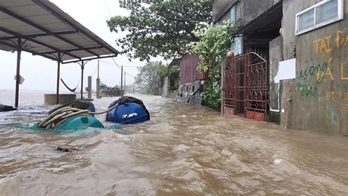
Rising sea level in Dien Chau commune, Nghe An province on August 25. (Photo: qdnd.vn) |
In the next 3 hours, the storm is forecast to move west-northwest at 10-15 km/h.
From 5:30 p.m. to 10:30 p.m., due to the impact of the storm, torrential rains are forecast to hit six northern and central provinces, including Phu Tho, Quang Ninh, Thanh Hoa, Nghe An, Ha Tinh, and Quang Tri. Rainfall reached 80-120 mm in Thanh Hoa, Nghe An, and Ha Tinh, even over 200 mm in certain areas.
Authorities have issued flash flood and landslide warnings across vulnerable wards and communes, including Vinh ward and mountainous areas in Ha Tinh.
Meteorologists cautioned that flash floods and landslides could endanger lives, disrupt transport, damage infrastructure, and impact agricultural production. Local administrations were urged to reinforce inspections, clear drainage systems, and prepare emergency measures.
Earlier on August 25, rainfall reached alarming levels at several monitoring points: 185 mm in Thanh Hoa’s Bai Thuong, 172 mm in Nghe An’s Yen Thuong, and more than 540 mm at Ha Tinh’s Thuong Tuy reservoir. Several reservoirs in Ha Tinh and Quang Tri also recorded over 300 mm.
Source: VNA