Heavy rains have caused rising water levels in the Tich, Bui, and Day rivers in Hanoi. As of 5 p.m. on August 26, the water level at Yen Duyet station on the Bui river reached 6.34m (0.34m above the alert level 1), while at Vinh Phuc station on the Tich river, it stood at 7.45m (0.55m below the alert level 3), with forecasts indicating further rises.
    |
 |
|
Thanh Hoa issues an urgent directive on addressing the aftermath caused by Typhoon Kajiki and responding to post-storm flooding. (Photo: qdnd.vn) |
To ensure dyke safety, the municipal Department of Agriculture and Environment is ordered to direct relevant agencies to inspect, review, and implement dyke protection plans, including safeguarding vulnerable sections, addressing unresolved incidents, and keep a close watch on unfinished dyke construction works.
It is also tasked with directing relevant agencies to mobilize forces and strictly carry out dyke patrols during the flood season, ensuring early detection and prompt response to any incidents; and keeping close watch on floodwater levels and dyke conditions, and report any issues in a timely manner to the Department of Dyke Management and Disaster Prevention for coordinated action.
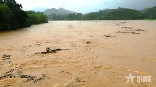
The same day, the Chairman of Thanh Hoa provincial People’s Committee issued an urgent directive on addressing the aftermath caused by Typhoon Kajiki and responding to post-storm flooding, aiming to stabilize local conditions and residents’ lives.
Heavy rains and strong winds from the storm have caused flooding and isolating several areas of Thanh Hoa, damaging homes and crops. In Cam Thuy commune, downpours from August 24-26 combined with floodwaters from the upper Ma river forced the evacuation of 185 households, with a total of 685 residents, to safe areas.
Forecasts show that from August 26 through the afternoon of August 27, the locality will continue to experience moderate to heavy rain, with some areas seeing very heavy downpours and thunderstorms.
Residents are advised to limit travel during heavy rains and floods. Local units are required to deploy checkpoints to guide and assist safe traffic, and assign personnel to directly oversee flood response in high-risk areas, especially villages vulnerable to isolation or landslides.
Localities were instructed to ensure the safe operation of irrigation and hydropower reservoirs and dyke systems, proactively prepare response plans to protect residents in case of emergencies, and keep rescue forces, equipment, and resources ready for timely deployment in critical situations.
Attention will be paid to repairing damaged houses, schools, and medical facilities, and provide temporary shelters for households that lost their homes to the typhoon, in line with regulations.
According to the provincial Civil Defense Command, Typhoon Kajiki has so far damaged 37 houses, inundated 1,935 others, and destroyed two school sites. About 529.4 hectares of rice have been submerged or flattened, while a 25-metre section of the Chu river’s right dyke in Dong Tien commune has eroded. Landslides have also disrupted traffic, leaving many villages isolated and flooded.
Meanwhile, authorities in the Northern province of Phu Tho evacuated 378 households from areas at risk of landslides and flash floods to safe locations, according to a preliminary report from the provincial Sub-Department of Irrigation and Water Resources.
From August 24 to 26, the levels of many rivers in the locality reached alarming thresholds.
The storm injured one person in Yen Lap commune, and damaged 152 houses. Many areas of rice, corn, and cassava were inundated or flattened, while aquaculture ponds overflowed, and landslides disrupted traffic in several places.
Source: VNA