In 1959, under the leadership of the Politburo and President Ho Chi Minh, the General Military Commission (now the Central Military Commission of the Communist Party of Vietnam) established a "special military task force" (later known as Group 559) tasked with constructing a strategic supply route through the rugged Truong Son Mountain Range to support the Southern battlefield. This route was later named Truong Son Trail - Ho Chi Minh Trail.
    |
 |
|
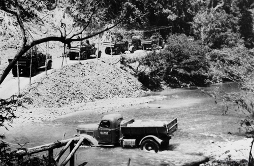
Transporting rocks to build the Truong Son Trail. (File photo) |
The construction and development of this strategic route evolved through various stages, closely tied to the revolutionary progress in Southern Vietnam during the resistance war against the U.S. Vietnamese soldiers and civilians braved relentless bombings, harsh weather conditions, and unforgiving terrain to clear paths, establish routes, and transport personnel and supplies to the frontlines.
From its initial state as a network of narrow trails used for manual carrying and hauling, the Truong Son supply route evolved over 16 years (1959–1975) into an extensive transportation system stretching thousands of kilometers. It comprised five vertical trunk roads, 21 horizontal routes, nearly 17,000 km of roads for motorized vehicles, over 3,000 km of communication pathways, about 1,400 km of fuel pipelines, along with numerous river crossings and communication lines along the route.
This strategic network became a lifeline, linking Northern Vietnam – the rear base – with the Southern battlefield while supporting multiple combat fronts with diverse transport methods.
The legendary Ho Chi Minh Trail itself was also a fierce battlefield where Vietnamese forces faced relentless enemy attacks. The U.S. imperialists and the puppet Saigon regime swiftly identified the trail's vital strategic role in sustaining resistance efforts in the South, a factor that could determine the success or failure of their invasion. Consequently, they spared no effort in attempting to block and destroy the trail.
In response, they launched extensive campaigns to destroy it, transforming the trail into a testing ground for advanced warfare tactics and cutting-edge weaponry. Employing strategies like "interdiction tactics" and "strangulation warfare," they sought to sever this vital supply link.
Despite these efforts, under the wise leadership of the Party, the Central Military Commission, and the Ministry of National Defense, Vietnamese soldiers and civilians displayed remarkable bravery, resilience, and ingenuity to overcome every difficulty, hardship, and sacrifice, defeating all ruses of the enemy and ensuring a continuous flow of supplies and personnel to the Southern frontlines.
In its 16 years of operation, Truong Son Trail transported over one million tons of weapons, equipment, and other supplies while facilitating the movement of over two million soldiers to the frontlines and evacuating tens of thousands of wounded troops to the North for treatment. During the critical 1975 Spring General Offensive and Uprising alone, the route delivered 413,450 tons of vital supplies, marking a significant contribution to Vietnam's ultimate victory.
A new chapter in national development
If Truong Son Trail symbolized the burning desire for national independence and reunification during wartime, in peacetime, Ho Chi Minh Trail has assumed a new mission of driving national development.
Recognizing the strategic significance of Ho Chi Minh Trail as both a critical security - defense route and a vital economic development corridor, the National Assembly issued Resolution No. 38/2004/QH11 on December 3, 2004, approving the investment policy for the Ho Chi Minh Highway construction project.
On February 15, 2007, the Prime Minister signed Decision No.242/QD-TTg, approving the master plan for Ho Chi Minh Highway. This ambitious project spans 30 provinces and cities, beginning at Pac Bo (the Northern border province of Cao Bang) and ending at Dat Mui (the Southernmost province of Ca Mau). The total planned route length is 3,167 km, including a 2,667 km main route and a 500 km western branch.
On April 5, 2000, at the Xuan Son Ferry Terminal in Bo Trach district, the Central province of Quang Binh, the Prime Minister officially launched work on Ho Chi Minh Highway. Today, over 90% of the project has been completed, and despite not being fully operational yet, the road has been demonstrating its critical role in enhancing connectivity among regions, easing pressure on National Highway 1A, fostering socio-economic development, and guaranteeing border security and defense.
The highway has also helped bolster trade links with Laos and Thailand, positioning itself as an important component of the East-West Economic Corridor in North-Central Vietnam. In Ha Tinh province, it has facilitated trade with Laos through the Cau Treo International Border Gate. In Quang Binh, it has enabled economic zone expansion and boosted tourism at Phong Nha - Ke Bang National Park and historical relic sites. In the Central Highlands, the route has linked coffee and pepper production zones with domestic and international markets.
By capitalizing on this road's potential, localities have fostered agricultural growth, attracted investment, and improved living standards, thereby contributing significantly to Vietnam's sustainable development journey.
Source: VNA