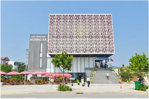
The Hoang Sa exhibition center, located on Hoang Sa street, Son Tra district, central Da Nang city, displays and archives historical documents, exhibits and images which testify to Vietnam’s legitimate sovereignty over the two archipelagos.
    |
 |
|
The Hoang Sa exhibition center is located on Hoang Sa street, Son Tra district, central Da Nang city. |
Since being put into operation in March 2018, the exhibition center has become a place to popularize and affirm Vietnam's sovereignty over the Hoang Sa and Truong Sa archipelagos, thereby promoting the spirit and will to protect the homeland’s territory among the people.
Built on a total area of 1,296 sq.m, the center holds special political significance as it displays information, documents and images evidencing Vietnam’s exploration, establishment and protection of the country’s sovereignty over the Hoang Sa and Truong Sa archipelagos.
The center has the shape of the sovereignty seal in the Nguyen Dynasty (1802 - 1945), which is meant to show that Vietnam established and exercised sovereignty over Hoang Sa very early. Notably, that King Minh Mang of the Nguyen Dynasty put the seal on a document setting up the Hoang Sa flotilla was one of the important landmarks in the establishment and exercise of this indisputable sovereignty.
Exhibits are showcased in five topics, namely the geographical location and natural conditions of Hoang Sa, Hoang Sa in Vietnam’s ancient documents before the Nguyen Dynasty, Hoang Sa in documents during the Nguyen Dynasty, evidence of Vietnam’s sovereignty over Hoang Sa from 1945 to 1974, and evidence of the sovereignty since 1974.
Each picture, document, map and exhibit displayed at the center is valuable in terms of historical and legal foundation proving Vietnam's sovereignty over the Hoang Sa and Truong Sa archipelagos. It also has sacred treasures strengthening the pride and the will towards the preservation and protection of the homeland’s islands of over 100 million Vietnamese people living inside and outside the country.
For example, plate No.24 inscribed with part of the 10th volume of “Dai Nam thuc luc tien bien” (Early Chronicle of Dai Nam) displayed at the center says, “In the sea off the coast of Vinh An commune of Binh Son district, Quang Ngai province, there are more than 130 sand banks … stretching for several thousands of miles called Van ly Hoang Sa – the eternal yellow sand bank. On these sand banks, there are fresh water and seafood like sea cucumber and hawksbill turtle… In the early period of the dynasty, a Hoang Sa flotilla was set up with 70 members from An Vinh commune. Every year, they begin sailing in March and reach the bank in about three days to seek natural produce and then return to hand over the produce in August.”
A map compiled in the Le Dynasty (18th century), a part of Thien ha ban do (a map of Vietnam’s air and land territories), is being displayed at the Hoang Sa exhibition center.
It includes a description of “Bai Cat Vang” (Yellow Sand Bank) offshore Quang Ngai province in Nom script (the Chinese character-based old Vietnamese script) in a footnote above the map.
“Yellow Sand Bank is about 400 miles in length and 20 miles in width in the middle of the sea,” it said.
“Every year in the last month of winter, 18 boats go there to collect gold and silver. It takes one day and a half to go from Dai Chiem or Canh Sa estuaries to the beach.”
The exhibits have introduced to a large number of Vietnamese people and international friends valuable information about exploring, establishing and protecting Vietnam's sovereignty over the Hoang Sa and Truong Sa archipelagos, especially the Hoang Sa archipelago.
The center officially became a tourist destination of Da Nang city, attracting a large number of people to visit and study since December 2019.
Source: VNA