Under the document, the ministers of national defense, public security, agriculture and environment, construction, industry and trade, science and technology, education and training, and health, as well as the chairpersons of the People's Committees of localities from central Quang Ngai northwards, are requested to stay alert and avoid letting down their guard, arrange personnel for closely tracking the storm’s developments and local conditions, review and update response plans, and be fully prepared to deploy measures against the super typhoon with the utmost urgency.
    |
 |
|
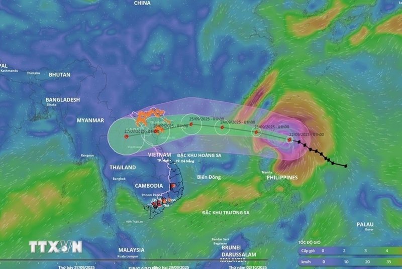
Forecast of the movement direction of super Typhoon Ragasa |
Authorities must anticipate worst-case scenarios to protect lives, minimize property damage, and prevent any passivity or surprise in all situations.
Attention must be paid to accounting for all local vessels operating at sea and along the coast, ensuring that all owners and captains are informed of the storm’s developments and projected path, providing guidance for vessels to move away from and not enter dangerous areas, and directing them to safe shelters.
Response measures must be taken at sea, on island, and in coastal and mainland areas as soon as possible, the dispatch noted, demanding strong heed to reinforcing housing, infrastructure, and sea dykes; minimizing damage to production, especially coastal farming; and assisting locals to harvest farm produce early.
The document also underlined the need to gear up plans, personnel, and equipment for evacuating residents from unsafe areas before the storm makes direct landfall, and for serving rescue and relief operations in case of emergencies.
Specific tasks were also assigned to each ministry and media agencies.
Super Typhoon Ragasa continues to intensify as it approaches the East Sea (aka South China Sea), bringing powerful winds, towering waves, and warnings of flash floods and landslides in northern mountainous provinces of Vietnam.
At 7 a.m. on September 22, the storm’s eye was located at 19.3 degrees North latitude and 123.1 degrees East longitude, about 160 km northeast of Luzon Island in the Philippines. Ragasa packed maximum winds of 202-221 km per hour (equivalent to Level 17 on Vietnam’s wind scale), with gusts exceeding Level 17, and was moving west-northwest at around 20 km per hour, according to the National Center for Hydro-Meteorological Forecasting.
By 7 a.m. on September 23, Ragasa is forecast to be in the northeastern region of the northern East Sea with sustained winds of Level 17, gusting above Level 17. It will likely continue to strengthen as it tracks west-northwest at 20 km per hour and enters East Sea. Disaster risk level has been set at Category 4, the second-highest warning.
By 7 a.m. on September 24, the storm is expected to be about 370km east of China’s Leizhou Island, maintaining winds of Level 16-17 and gusts of over Level 17; moving west-northwest at 20 km per hour.
The eastern part of the northern East Sea is forecast to see winds gradually strengthening from Level 8-9 to Level 10-14, and near the storm’s eye reaching Level 15-17 with gusts above Level 17. Waves could rise over 10 meters, making the sea extremely rough. All vessels in the affected waters face very high risks from squalls, strong winds, and high seas.
The forecasting center said the storm is likely to directly hit the northern and north-central regions of Vietnam, urging constant updates of its developments.
Source: VNA