January 13, 2021 | 21:04 (GMT+7)
Vietnam-Cambodia border topographic maps handed over to border posts
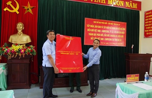
PANO - The Vietnam-Cambodia border topographical maps with a scale of 1:25,000 were handed over to local departments, agencies, authorities, and border posts of seven border communes of Gia Lai province on January 12 at the Border Post of Le Thanh International Border Gate.
The event was held by the Ministry of Foreign Affairs, the standing agency of the State Steering Committee on Land Border Demarcation and Marker Planting, and the steering committees for border demarcation and marker planting of the Ministry of Natural Resources and Environment and of Gia Lai province.
    |
 |
|
The maps are symbolically handed over to the steering committee for border demarcation and marker planting of Gia Lai province. (Photo: baobienphong.com.vn) |
At the event, the organizers also provided map training for the recipients.
The maps are legal and technical documents that fully reflect the land border demarcation and marker planting results the two countries have recorded so far, and also form an inseparable part of the Vietnam-Cambodia protocol on land border demarcation and marker planting. It was signed on October 5, 2019 and became effective on December 22, 2020.
The maps were created, printed, and bound under the strictest technical requirements for map publications, to ensure accuracy and objectivity. Vietnam and Cambodia contracted the Blom Infor Company, later renamed NIRAS Mapping A/S, of Denmark, to produce the maps.
The maps, together with the two legal documents signed in 2019 and the modern border marker system are considered major achievements of the two countries after more than 36 years of the two countries’ border experts negotiating the issues negotiations in the goodwill spirit and in a constructive manner.
Translated by Song Anh