August 01, 2020 | 20:22 (GMT+7)
Storm Sinlaku enters East Sea, downpours occur in northern, central regions
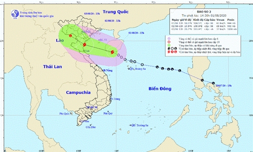
A tropical depression developed into a storm, named Sinlaku, at noon of August 1, becoming the second to enter the East Sea since the beginning of this year.
    |
 |
|
The strongest wind close to the storm’s eye has reached level 8 |
According to the National Centre for Hydro-Meteorological Forecasting, at 1pm on August 1, the storm’s centre was at 18.5 degrees north and 109.5 degrees east, around 450km southeast of the coast of Thai Binh - Nghe An provinces. The strongest wind close to the storm’s eye has reached level 8 (60-75km per hour), with gusts at level 10.
In the next 24 hours, the storm is forecast to move in the west-northwest direction at a speed of 15-20km.
The storm is forecast to hit the northern and north central localities on August 3 before weakening into a tropical depression.
Due to impact of the storm, northern and central localities will suffer heavy rains from August 1 afternoon to August 2 evening.
Source: VNA