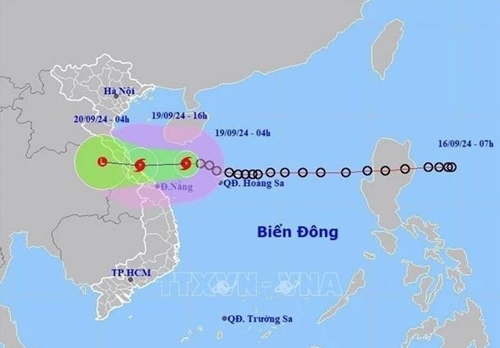
The dispatch, sent to authorities of 10 Central provinces and cities from Thanh Hoa to Binh Dinh and relevant ministries, underscored the imminent threat. As of 10 p.m. on September 18, the storm was located around 320km East of Da Nang, packing maximum winds of level 7, with gusts up to level 9.
    |
 |
|
The movement trajectory of the storm |
From midnight to 6 p.m. on September 18, the region was already inundated with heavy rains, with some areas recording downpours exceeding 250 mm.
The National Center for Hydro-Meteorological Forecasting warned of strong winds and high waves along the coast from Ha Tinh to Quang Nam starting early September 19, with wind speeds potentially reaching levels 6-7. Heavy rainfall is expected to lash the region from Thanh Hoa to Binh Dinh, exacerbating the risk of flooding.
The PM urged chairpersons of the above localities to vigilantly monitor the situation and take immediate actions to safeguard vessels, marine activities, and lives. Response plans must be activated to mitigate the impact of storms, flooding, landslides, and mudslides. Hydroelectric and irrigation reservoirs should be managed effectively to alleviate downstream flooding and prevent consecutive deluges.
All necessary effort must be exerted to ensure no one is left hungry, cold, without shelter or lacking clean water, he stressed, instructing swift post-disaster recovery to restore normalcy and resume production and business activities.
Specific tasks were also assigned to relevant ministers and the media to ensure seamless implementation of the response plans.
Rainfalls ranging from 100-300 mm are expected across the North-central and Central-central regions from September 19-20.
Source: VNA