At the event, the Minister of Agriculture and Rural Development Nguyen Xuan Cuong, Head of the Steering Committee for Natural Disaster Prevention and Control, asked relevant localities to actively contend with the storm in order to minimize any human or material losses.
Particular attention must be paid to calling upon ships at sea, especially those lying in the projected path of the storm, to find shelter, as well as evacuating people from dangerous areas, and preparing necessary tools for all possible search and rescue missions.
    |
 |
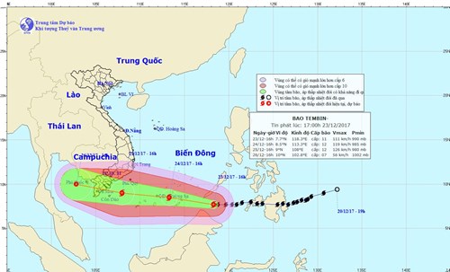
| Map featuring the development of the typhoon Tembin |
According to the National Center for Hydro-meteorological Forecasting, typhoon Tembin is moving West-Northwest at a speed of 20-25km per hour and entered the East Sea (South China Sea) on the night of December 23.
In the next 24-48 hours, the storm is predicted to move West at a speed of 25km per hour and to keep gaining strength. By approx. 10am on December 25, the storm will be about 300-400km East of the coastal provinces from Ba Ria-Vung Tau to Ca Mau, with winds expected to gust between 100 and 135km per hour (up to level 15), while the risk of natural disaster is projected at level 3.
More than 67,500 boats are thought to be operating in waters from Quang Nam to Ca Mau and Kien Giang, with 29 landslide-prone areas are known to span 121km near coastal residential areas. Attention will be on a number of sea dykes from Quang Nam to Ca Mau which have a total length of 993.4km and are capable of ensuring safety against storms up to level 9.
* Additionally, 137,000 cadres and soldiers along with 4,429 vehicles have been placed on standby in case they are required to carry out search and rescue and other tasks to minimize possible losses to life or property caused by the storm.
* The Prime Minister has also issued an urgent telegram to encourage relevant ministries, agencies, and localities to actively cope with the storm.
Translated by Chung Anh