November 05, 2020 | 16:37 (GMT+7)
Storm Goni to abate to tropical depression
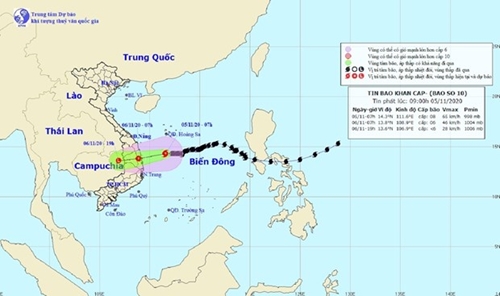
Storm Goni is forecast to weaken to a tropical depression by 1 a.m. on November 6, with its center on the sea off the coast of the South-Central localities from Quang Ngai to Phu Yen, according to the National Center for Hydro-Meteorological Forecasting.
At 1 a.m. on November 5, the storm’s eye was about 290 km to the south of Hoang Sa (Paracel) Archipelago, sustaining winds of up to 60-75 km per hour.
From 1 a.m. on November 5 to 1 a.m. on November 6, it will move west-southwest at about 10 km per hour and subside to a tropical depression with the strongest winds of some 40-60 km per hour.
    |
 |
|
The movement of Storm Goni in the East Sea (South China Sea) |
Between 1 a.m. and 1 p.m. on November 6, the depression is predicted to move mainly west-southwest at some 10 km per hour, make landfall from Quang Ngai to Khanh Hoa, and continue to weaken to a low-pressure area.
At that time, the center of this low-pressure area will be in the North of the Central Highlands with the strongest winds of less than 40 km per hour.
On November 5 and 6, the South-Central provinces of Quang Nam, Quang Ngai, and Binh Dinh are likely to record 250-350 mm downpours. Meanwhile, rainfall of 100-200 mm is projected for the surrounding localities of Thua Thien - Hue, Da Nang, Kon Tum, Gia Lai, and Phu Yen.
The North-Central provinces from Ha Tinh to Quang Tri will experience 100-200 mm rainfall from November 5 to 7.
Source: VNA