September 19, 2022 | 17:17 (GMT+7)
Exhibition on Hoang Sa, Truong Sa held in Dak Lak province
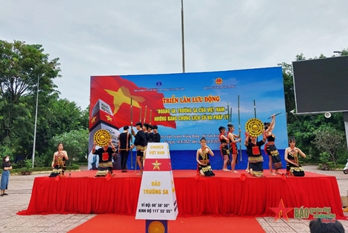
PANO – The Dak Lak provincial Department of Information and Communications, in coordination with Krong Bong district’s People’s Committee and Dak Lak Museum, from September 16 to 18, held a mobile exhibition themed “Hoang Sa (Paracel) and Truong Sa (Spratly) archipelagoes of Vietnam – Historical and legal evidence.”
The exhibition introduced more than 100 images about documents and maps with six themes, including “Maps of Vietnam under dynasties” (Sixteenth - nineteenth centuries) affirming Vietnam’s sovereignty over the two archipelagos of Hoang Sa and Truong Sa; the extract and the manuscript of the Nguyen Dynasty showing Vietnam’s sovereignty over the Hoang Sa and Truong Sa archipelagos.
The exhibition also introduces a map published in Western countries (16th - 19th centuries) acknowledging Vietnam’s sovereignty over the two archipelagos; a map of China published by Western countries and China (16th - 20th centuries) affirming that Hoang Sa and Truong Sa do not belong to China; images and documents about Hoang Sa before 1975; some current photos of Truong Sa and activities of naval officers and soldiers and people on the islands.
    |
 |
|
An art performance during the exhibition |
This was an occasion to publish information, historical and legal evidence on Vietnam’s sovereignty over sea and islands as well as introducing the image of the country and Vietnamese people to the locals in Krong Bong as well as neighboring districts.
The information dissemination held important significance, affirming the country’s sovereignty over Truong Sa and Hoang Sa, while promoting solidarity and people’s awareness of protecting national sovereignty over sea and islands.
Translated by Minh Anh