The disaster risk warning level for flash floods, landslides, and ground subsidence due to heavy rains and flows is rated at level 1, except in Nghe An, where it is raised to level 2.
Such disasters may severely damage the environment, threaten lives, disrupt traffic, hinder transport, and destroy residential and economic infrastructure, causing losses to production and socio-economic activities.
    |
 |
|
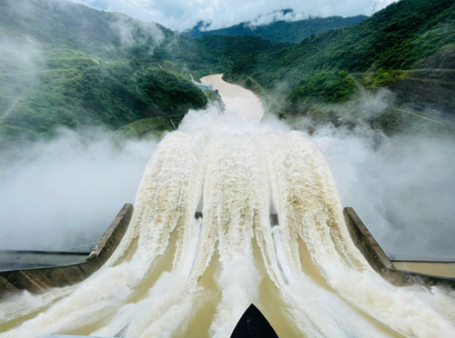
The Ban Ve Hydropower Reservoir flexibly regulates water discharge to reduce downstream flooding. |
In the next 24-72 hours, high tidal levels are also expected along the northern coastline. Forecasts indicate peak water levels could reach 4.6m at Cua Ong, 4.1m at Hon Dau, and 3.1m at Hon Ngu. The disaster risk level due to tidal surges is rated level 1.
Low-lying coastal and riverside areas outside dyke systems may experience flooding between 1:00 p.m. and 5:00 p.m. daily. High tides will also slow drainage across river systems. In the early morning, strong offshore currents during tidal outflows could pose risks to maritime and tourism activities, particularly near ports and beaches.
To cope with rising water levels and minimize downstream flooding, the Ban Ve hydropower plant in Nghe An province has begun flexible water discharge based on inflow volumes to balance flood reduction and dam safety.
At 9:00 p.m. on July 22, inflow to the Ban Ve reservoir surged to 9,543 cubic meters per second, approaching the design flood threshold of 10,500 cubic meters per second, equivalent to a 0.02% flood recurrence interval.
|
|
 |
|
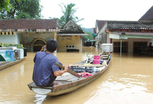
By the morning of July 23, hundreds of houses were inundated, and sections of National Highway 7 remained cut off. |
According to Le Van Luong, Secretary of the Party Committee of Tuong Duong commune, the emergency discharge from the Ban Ve Hydropower Plant caused floodwater to rise rapidly overnight. Local authorities and emergency forces assisted residents with evacuation throughout the night. By the morning of July 23, hundreds of houses were inundated, and sections of National Highway 7 remained cut off.
Late on July 22, Acting Minister of Agriculture and Environment Tran Duc Thang sent an official dispatch to relevant agencies, requesting swift action to cope with prolonged heavy rainfall and rising water levels caused by Typhoon Wipha’s circulation.
According to the official dispatch, torrential rain on July 22 triggered severe flooding in the upper reaches of the Ca River, where water levels have surpassed alarm level 3. Downstream sections are forecast to rise to the same level in the coming hours. The disaster risk level for flooding has been classified as level 3.
Authorities in Nghe An and Thanh Hoa provinces are requested to urgently review evacuation plans and relocate residents from low-lying areas, riverside communities, and zones at a high risk of landslides and flash floods to safe locations.
Source: VNA