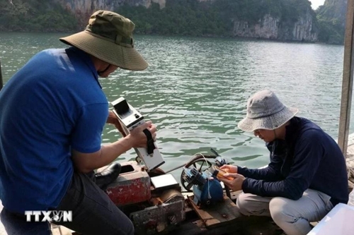
Rapid socio-economic development in recent years has led to growing environmental challenges in areas like Ha Long Bay and Cua Luc of Quang Ninh province, particularly the degradation of seawater quality, which threatens unique marine ecosystems. Traditional monitoring methods such as on-site sampling and laboratory analysis have proven to be costly, time-consuming, and limited in coverage.
    |
 |
|
The research team collects seawater samples in Ha Long Bay and Cua Luc. |
In response, researchers from the Vietnam Space Center under the Vietnam Academy of Science and Technology and the Institute of Geophysics of the Polish Academy of Sciences have developed an innovative, cost-effective approach using AI and satellite imagery. This modern method allows for continuous, large-scale seawater monitoring.
A modern and integrated approach
According to Dr. Vu Anh Tuan, Deputy Director General of the Vietnam Space Center and head of the project, this is the first study in Vietnam to simultaneously employ Sentinel-2 satellite data, advanced machine learning algorithms, and the Google Earth Engine (GEE) cloud computing platform to model and monitor key seawater quality parameters.
Using this model, the research team created spatial-temporal maps of water quality, enabling early detection of pollution risks and long-term trend analysis in Ha Long Bay and Cua Luc. These maps serve as valuable tools for water resource management, environmental protection, and sustainable coastal development planning.
Dr. Tuan emphasized the novelty of the study lies in its creative and integrated use of remote sensing, AI, and cloud computing technologies to address the complex issue of marine water quality. The research overcame challenges such as data scarcity and provided high-value, practical insights.
The machine learning models were calibrated and validated to achieve over 73% accuracy. Seasonal and annual maps of water quality indicators were also developed, offering a comprehensive view of changes over time.
Beyond its immediate findings, the study paves the way for broader applications of remote sensing and machine learning in environmental monitoring, especially in areas facing resource constraints.
Toward nationwide deployment
Encouraged by promising results, the research team plans to expand the model's application to coastal areas across Vietnam. While each marine area presents unique characteristics, the study’s foundational framework can be adapted to ensure accurate and region-specific results.
Ultimately, the team envisions a comprehensive monitoring system capable of continuously tracking seawater quality parameters nationwide. This system would provide essential data for planners and policymakers, issue timely warnings about environmental risks, and support key sectors such as aquaculture and marine-based economies.
Assoc. Prof., Dr. Pham Quang Vinh, a member of the evaluation council under the Vietnam Academy of Science and Technology, lauded the research as a strong example of integrating AI with remote sensing for coastal water studies. He noted that the project’s findings, published jointly by the Vietnamese and Polish sides in a high-ranking SCIE Q1 international journal, highlight the success of scientific collaboration between the two nations.
Source: VNA