July 22, 2025 | 22:28 (GMT+7)
Typhoon Wipha triggers widespread rain, winds, flooding risks on Jul.22
Typhoon Wipha has unleashed torrential rain across multiple regions as it barrels towards Vietnam, with rainfall exceeding 200mm, sparking concerns over flooding and landslides.
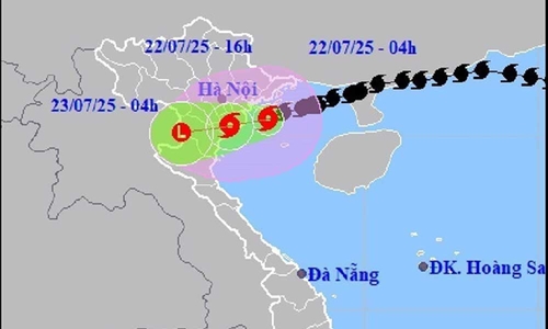
At 7:00 on July 22, Wipha was located some 202 kilometers south-southwest of Quang Ninh, 67 kilometers southeast of Hai Phong, 25 kilometers east of Hung Yen, and 45 kilometers northeast of Ninh Binh. The strongest winds near the storm's center reached level 9 (75-88 kilometers per hour), with gusts up to level 11. It is forecast that the storm will continue moving west-southwest at around 15 kilometers per hour over the next three hours.
    |
 |
|
The typhoon's path as of 7 a.m. on July 22. |
The National Centre for Hydrometeorological Forecasting said wind speeds over land from Hai Phong to Thanh Hoa are expected to reach level 6 with gusts up to level 8 by 7 pm on July 22. The typhoon is forecast to weaken into a low-pressure system over upper Laos by 7 am on July 23.
The special zones of Bach Long Vy, Co To, Van Don, and Cat Hai, and Hon Dau island, are experiencing winds of up to level 8, with areas near the storm's path facing winds as high as level 10 and wave heights ranging from two to four meters. Extremely rough sea conditions are forecast.
Hydrometeorological experts warned that maritime and coastal land conditions remain extremely dangerous for any vehicles and infrastructure operating in the areas.
Strong winds are expected to cause significant damage, including uprooted trees, downed power poles, and torn-off roofs.
Inland regions from Quang Ninh to Thanh Hoa, as well as other parts of the northern region and Ha Tinh province, are forecast to experience heavy rainfall, with some areas receiving up to 150mm in a three-hour period. The downpours are expected to trigger flash floods and landslides, especially in mountainous areas.
Source: VNA