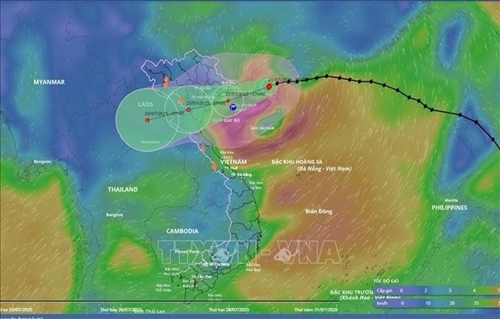
At 10:00 a.m., the storm’s center was positioned at around 21.2 degrees North and 109.6 degrees East, approximately 190km southeast of Quang Ninh, 310km east of Hai Phong, and 360km east-northeast of Ninh Binh. Maximum sustained winds near the storm’s center reached Level 9 (75–88 km/h), with gusts up to Level 11. Wipha was moving west-southwest at a speed of 10–15 km/h.
    |
 |
|
The position and movement direction of Typhoon Wipha from the disaster monitoring system as of 10:00 a.m. on July 21, 2025. |
Forecasts indicate that by 10:00 pm on July 21, the storm will remain in northern waters of the Gulf of Tonkin, potentially intensifying as it continues west-southwestward. Wind speeds may increase to Levels 10–11, with gusts reaching Level 14. Areas likely to be affected include northern parts of the East Sea (South China Sea), the Gulf of Tonkin, and inshore zones from Quang Ninh to Ninh Binh.
By 10 am on July 22, the storm will be on the waters between Hai Phong and Thanh Hoa, continuing in a west-southwest direction at 10–15 km/h. Wind warnings remain at Levels 10–11, with gusts up to Level 14. Coastal and inland regions from Quang Ninh to Nghe An are within the high-risk zone.
It is projected to be in northern Laos by 4 pm on July 23 and weaken into a low-pressure area.
Meteorologists warn that sea and coastal areas are in extreme danger, and all maritime vessels and structures in the storm’s path are unsafe. Boats and structures risk capsizing, damage, or submersion from strong winds, thunderstorms, tornadoes, and high waves.
From the evening of July 21, coastal areas from Quang Ninh to Nghe An are forecast to experience increasing winds of Levels 7–9, with gusts up to Level 11. In areas near the storm’s center, gusts could reach Level 14. Inland areas, including those of Hai Phong, Hung Yen, Ninh Binh, and Thanh Hoa, may encounter wind levels of 6, gusting up to Levels 7–8.
Heavy rainfall is expected from July 21 through the night of July 22 across the Northeast, Red River Delta, and the north-central provinces of Thanh Hoa and Nghe An, with accumulations ranging from 170 to 280 mm, and some areas exceeding 450 mm. Other places in the North and central Ha Tinh province may record 80–160 mm, even over 250 mm.
Authorities warn of significant flooding risks in low-lying, urban, and industrial areas, especially in the Red River Delta, Thanh Hoa, and Nghe An. Flash floods in small streams and landslides on mountain slopes are also of concern. The Vietnam Meteorological and Hydrological Administration has activated real-time warnings for flash floods and landslides at https://luquetsatlo.nchmf.gov.vn.
Experts emphasize that landslides can continue to occur even after the storm has passed due to lingering soil saturation. Additionally, prolonged rainfall in the storm’s wake is forecast to continue affecting northern Vietnam and parts of northern Laos as the weather system broadens its influence.
Source: VNA