August 31, 2023 | 17:37 (GMT+7)
Typhoon Saola enters East Sea
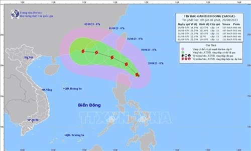
Typhoon Saola entered the Northeastern waters North of the East Sea (South China Sea) on August 30 afternoon, becoming the third storm hitting the area this year, said the National Center for Hydro-Meteorology Forecasting.
    |
 |
|
The predicted path of Storm Saola (Photo: National Center for Hydro-Meteorology Forecasting) |
At 4p.m., its eye was at approximately 20.5 degrees North latitude and 119.8 degrees East longitude, with the strongest wind near its center being 167-201km per hour. The typhoon is moving West-northwest at a speed of about 15km per hour.
In the next three days, it is predicted to get stronger and enter deeper into the area, located at 22.3 degrees North latitude and 115.3 degrees East longitude, about 370 kilometers East-southeast of Hong Kong (China) at 4p.m. on September 2.
In the following 72 to 120 hours, the typhoon will primarily move West-southwest at a speed of 5-10km per hour, with its intensity likely to gradually decrease.
During the period, the storm is forecast to cause rough seas in the waters.
As a result of the storm, the center said from the evening of August 30 to September 1, the Southern Central Highlands and South-eastern region will experience light to heavy rain and scattered thunderstorms, with rainfall expected to range from 50-100mm to more than 150mm. The Northern Central Highlands and South-western region will see showers and thunderstorms, with rainfall of 30-50mm, and even over 90mm in some areas.
From the evening of August 30 to August 31, the central and southern parts of the Central region will experience scattered showers and thunderstorms, with rainfall of 10-30mm.
Source: VNA