According to the National Center for Hydrometeorological Forecasting, early on August 22, strong winds of level 8 (62-74 km/h), with gusts up to level 9, were recorded at Bach Long Vi special zone in Hai Phong city, while winds reached level 6, with gusts up to level 9, in Co To special zone in Quang Ninh province.
    |
 |
|
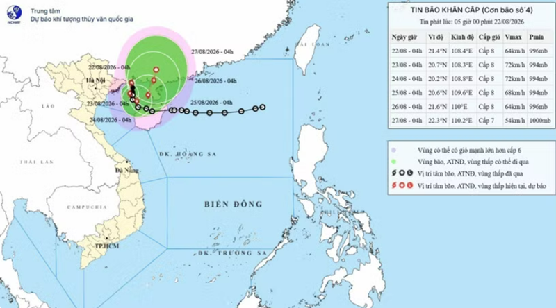
Storm Narra's projected path as of 7:00 on August 22 (Photo: National Center for Hydro-Meteorological Forecasting) |
At 4 am, the storm's center was about 130km northeast of Bach Long Vi. The strongest winds near the center were at level 8, with gusts up to level 10. The storm was moving slowly northward at about 3km per hour.
Forecasters said that early on August 23, the storm is expected to turn southward and move at around 3km per hour. Its center is forecast to be about 170km east of Hai Phong and 70km northeast of Bach Long Vi.
Areas likely to be affected include the Gulf of Tonkin, particularly Bach Long Vi, Van Don, Co To and Cat Hai special zones, as well as Hon Dau island.
The storm is predicted to cause widespread rain across the northern region on August 22, especially during the night, with moderate to heavy rain and thunderstorms, locally accompanied by torrential downpours. Quang Ninh is forecast to experience particularly heavy to torrential rain.
From August 22 through the night of August 23, northeastern provinces, southern Phu Tho province and Thanh Hoa province are expected to receive 70-150mm of rain, with some areas receiving more than 300mm. Quang Ninh could see 200-300mm, with some areas receiving more than 500mm. Lang Son, Bac Ninh and Hai Phong are forecast to receive 150-250mm, with several areas recording more than 400mm.
Rainfall could be particularly intense, exceeding 120mm in three hours, posing a risk of flash floods, inundation and landslides in vulnerable areas.
The rain is expected to persist through August 24.
Source: VNA